


ZLATI SPONZOR
![]()
SREBRNI SPONZOR
![]()
![]()
![]()
BRONASTI SPONZOR
![]()
![]()
![]()
![]()
![]()
![]()
![]()
![]()
![]()
![]()
![]()
![]()
![]()
![]()
![]()
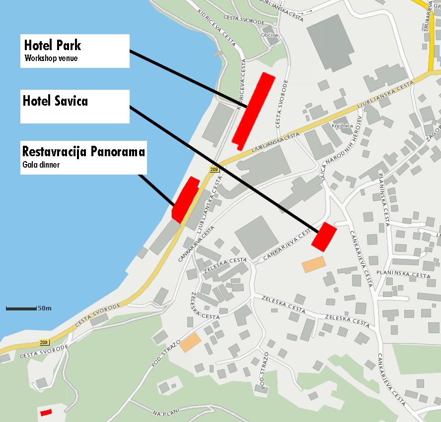
Meeting place
The Bled lake with an island
The lake was formed after the recession of the Bohinj glacier. It is up to 2120 m long and up to 1380 m wide, its maximum depth being 30.6 m and tectonic in origin. After the last Ice Age, the Bohinj glacier deepened the natural tectonic hollow and gave into its present form. The basin was filled with water when the ice melted. The lake has no large natural tributaries; it is fed only by a few springs.

The thermal springs in its north-eastern part are led into three swimming pools - Grand Hotel Toplice, Hotel Park and Hotel Golf. The picture-like image of Lake Bled is highlighted by the island in the western part of the lake.
The Vintgar gorge

This ravine in the immediate vicinity of Gorje, approximately 4 km north-west of Bled, was discovered by Jakob Žumer, the Major of Gorje, and the cartographer and photographer Benedikt Lergetporer in February 1891. The discovery was accidental and took place at a time when the water level of the Radovna river which flows through Vintgar was very low. They started their exploration in Spodnje Gorje and headed towards Blejska Dobrava. They made it through, the otherwise impassable ravine with great difficulty and discovered so much natural beauty that they decided to establish a construction committee. The gorge was arranged for visits, especially for visitors to Bled. It was opened to the public on 26th August 1893. The 1.6 km long Vintgar gorge carves its way through the vertical rocks of the Hom and Bort hills and is graced by the Radovna with its waterfalls, pools and rapids. The path leads you over bridges and Šumer’s galleries, and ends with a bridge overlooking the mighty 16 m high Šum waterfall. Due to its natural beauty, Vintgar was classified among the more important tourist sights in Slovenia and the number of visitors increases every year. From the Šum waterfall you can take the opportunity of walking up a picturesque footpath through Hom to St. Catherine-a historical church with a beautiful view. At the entrance, and at the Šum waterfall there are cafes serving refreshments. Access by car and buses is possible as far as the parking area in front of the entrance to the ravine.
The Pokljuka ravine

The Pokljuka ravine lies above the valley of the Radovna river and is only 1 km away from the village of Krnica, 2 km from Gorje and 7 km from Bled. You can reach these places by bus, but if travel via private transport note that you can go as far as the entrance to the ravine above Krnica, or alternatively access is also possible from Zatrnik. The ravine is 2 km long and 40 m deep in its most picturesque part. It was carved into limestone by water flowing from the Pokljuka glaciers, the only reminder of which is the Ribščica stream, a tributary of the Radovna river. Paths for visitors lead into the most beautiful central part of the ravine. The main path runs along its bottom, while side branches lead to the edges of the ravine and connect it with Zatrnik.
There are numerous natural sights. These include: a tributary gorge with a 22 m waterfall when it rains, the Pokljuška Luknja – a spacious rocky cave with a fallen ceiling, a large natural bridge 24 m above the bottom of the ravine, and small round fields called “vrtci” (little gardens) by the locals. You can get through the very narrow straits in order to reach the most beautiful “little garden” and a small natural bridge by way of wooden galleries. Above them, a path will lead you through a partisan crossing, the only passage through this deep ravine. A diversity of vegetation, from ferns to forest and mountain flowers, grows in its bottom and on its rocky walls. The paths are similar to mountain trails – we recommend good footwear. To make walking easier, Pokljuka walking sticks are available.
The cave under "Babji zob"

This approximately 300 m long cave is adorned with beautiful stalactite formations. A special feature of this cave is spiral stalactites, so-called helectites, and large calcite crystals which are rear in Slovenia. The tradition of visiting this cave dates back to the 19th century and has continued to the present day through the Bled Society for Cave Research. The Society in co-operation has arranged paths and electrical lighting to enable safe access to the cave.
The "Iglica" waterfall

In the abyss caves of Iglica, just above Bohinjska Bela, hides an 18 m high waterfall on the Suha stream. It falls over a vertical wall of Permian limestone.
In the village there is a signpost to the waterfall. The acces is very easy.
Next to the waterfall is a wooden stairway leading to the top the cliff. From up there one can get a great view of the surroundings.
On both sides of the waterfall there are bolded cliffs which offer several climbing routes of different levels to sport climbers.
Hills around the lake

Straža (642m)
This is the finest Bled viewpoint rising above the south-eastern lake shore. Mala and Velika Straža, covered with stand of linden aok and spruce trees offer a magnificent panorama. The Rikli Fitness Trail runs through meadows and wooded areas.
Osojnica
Take a winding trail from Velika Zaka to Mala Osojnica (685m). This peak offers the finest view of Lake Bled and its outlying areas, with the Karavanke, the Kamnik Alps and the Gorenjska plain in the distance. This is one of the favourite viewopints for photographers. All the well known panoramas of Bled have been shot from there. Another 20 minutes of walking separates us from the top of Velika Osojnica (756m)m, affording an even more sweeping view than Mala Osojnica.
Kuhovnica (714 m)
Starting out from the Kolodvorska cesta, we take the railroad underpass the residential high-rises and continue along the Aljaževa cesta, turning left on razgledna cesta. Then a winding trail branching off to the right takes us to the top of Kuhovnica, offering a marvellous panorama of Lake Bled and its surroungings.
Triglav national park
 The Triglav National Park, the only national park in Slovenia, lies in the immediate vicinity of Bled. It comprises one of the most beautiful and attractive areas of Slovenia, almost the entire Slovenian part of the Julian Alps. The territory of the National Park is very picturesque and varied. The highest mountain in Slovenia, Triglav (2864 m), after which the park was named, lies in its centre. From Triglav, deep and sharply cut valleys, mainly of glacial origin, open on all sides in the form of a fan.
The valleys and plateaux are covered by a carpet of green forests and meadows. Bold, high pointed mountain peaks rise above them, with dark and deep abysses. Clear mountain streams and small rivers run in the numerous gorges and beautiful ravines and troughs (Vintgar, Mlinarica, Mostnica) and flow into two larger rivers – the Sava and the Soča. The watershed between the Adriatic and the Black Sea runs between them. There are mountain lakes (the Triglav Lakes, Kriška Lakes, etc.) high in the mountains, and Lake Bohinj, the largest permanent natural lake in Slovenia. This magnificent and rugged landscape is inhabited by an extremely rich variety of flora and fauna with numerous rare and protected plant and animal species. At the edge of the park, where man has been master for many centuries, history and human culture have left their traces.  In more remote places you can find old farms and homes characteristic to this landscape, and mountains of interest, on many of which cattle still graye – the farms in this area are well known for their cheese production. The tides of World War I and II also surged into the Triglav National Park. During World War I, the present-day National Park was part of the long-lasting Soča Front. The front line ran high in the mountains (over the peaks of Rombon and Krn) and through the valley of the river Soča. In World War II, this area was known for its well-organised and popular Partisan movement.
Many sights in the Triglav National Park are described in detail in his book and can be visited by tourists, since they are accessible to many sights: Vintgar, Pokljuška Ravine, Lake Bohinj, Vrata valley, Vršič, Trenta, Pokljuka, etc. Well-marked footpaths and mountain trails and numerous mountain huts enable hikers to visit the higher areas of the National Park. Such trips are easier and safer if guided by experienced mountain guides.
Information:
Triglav National Park Management
Ljubljanska cesta 27, SI - 4260 BLED
Tel: +386 4 / 578 02 00
Fax: +386 4 / 578 02 01
www.tnp.si